 |
tsunamis:
tsunamis travel fast but not at infinite speed
a briefing document |

site
map |
| |
|
- introduction
a tsunami strikes
lack of preparation
sumatra tsunami present and
past
causes of tsunamis
end notes
|
advertising
disclaimer
If
you wish to donate to help tsunami relief work, you may do so through
the Amazon Honor System.
Click button below.

|
advertising
disclaimer
advertising
disclaimer |
introduction
In the context of the Sumatra tsunami, this briefing document gives information
on what is a tsunami, why do they occur, what are the results (wave size,
speed, distance travelled) and the effects on humanity and the environment.
As well as an wide-ranging investigation on tsunamis, this briefing document
at abelard.org provides illustrations and diagrams, together with numerous
links to specialised websites.
[Tsunami means “harbour wave” in Japanese.]
a
tsunami strikes
This
is probably the main source tracking the Sumatra tsunami. An
animation of the first few hours only, so far. Bangladesh appears
to have escaped lightly, despite having 17 million people living less
than one metre above sea level. Another
animation of the first three hours. These show weaker waves going
North and South, than the waves going East and West. This is probably
why much of India and Bangladesh has been little affected.

Seismic diagram of the Sumatran quake of 26 December 2004.
Image credit: UNESCO
terrestial consequences
of the sumatran undersea quake
- “The shockwave shortened the period of our planet's rotation
by some three microseconds. [...] [NASA] estimate that Earth now tilts
by an extra 2.5 centimetres in the wake of the jolt.” [Quoted
from nature.com]
- “The earth is regularly deformed by the daily passage of the
sun and moon, raising a tide in the earth of about 20cm, and the vibrations
we saw on Boxing Day shortly after the earthquake off the Indonesian
coast were of a similar magnitude on our instruments.”
—
A fortnight after, “equipment was showing much of the planet was
still ringing like a bell.[...] "The main signal we now see is
a steady oscillation of a few parts in 10 billion of normal gravity,
which corresponds to about a millimetre of vertical motion of the earth,"
” [Quoted
from Herald Sun]
A
tsunami animation of the Pacific region [2.4mb .mov file].
There is a good write-up from the overseers of the US Tsunami Service,
NOAA
and Tsunamis.
“The waves radiate outward in all directions from the disturbance
and can propagate across entire ocean basins. For example, in 1960 an
earthquake in Chile caused a tsunami that swept across the Pacific to
Japan. Tsunami waves are distinguished from ordinary ocean waves [1]
by their great length between peaks, often exceeding 100 miles in the
deep ocean, and by the long amount of time between these peaks, ranging
from five minutes to an hour. The speed at which tsunamis travel depends
on the ocean depth. A tsunami can exceed 500 mph in the deep ocean but
slows to 20 or 30 mph in the shallow water near land. In less than 24
hours, a tsunami can cross the entire Pacific Ocean.
“In the deep ocean, a tsunami is barely noticeable and will only
cause a small and slow rising and falling of the sea surface as it passes.
Only as it approaches land does a tsunami become a hazard. As the tsunami
approaches land and shallow water, the waves slow down and become compressed,
causing them to grow in height. In the best of cases, the tsunami comes
onshore like a quickly rising tide and causes a gentle flooding of low-lying
coastal areas.”
(See also radar
satellites capture tsunami wave images.)
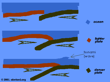
The behaviour of a tsunami
wave when caused by subduction [as happened with Sumatra]. With diagrams.

Mt Fuji seen from the sea, Hokusai, woodcut, 1834
When a wave hits the shore, it tends to act like a motorway pile-up to
varying degrees. This is called the ‘run up’.
A typical beach has a run up of 3; that is, a 5 foot wave will rise to
15 feet on beaching (three times the starting height of the wave).
This will, of course, depend on the beach slope. Naturally, a steep slope
causes greater run up than a gentle beach. Even greater run ups would
be expected in an inlet like a river or delta. Regions with run ups of
approximately 40 are known.
Various types of tsunami give different patterns
of waves formation and propagation, this is an area of study that
is rapidly developing and involves computer modelling, real-world and
experimental data. Study of the Shoemaker-Levy comet, which crashed into
Jupiter in 1994, has resulted in increased confidence in computer models.
A common convenient, if grim, measure of the energy is by megatons of
TNT, or numbers of Hiroshima-type bombs. Hiroshima was rated at about
15,000 tons of TNT.
sumatra
tsunami present and past
- “Many who escaped death in what was possibly the deadliest
tsunami in more than 200 years now face hunger and disease. The United
Nations mobilized what it called the biggest relief operation in its
history [...] ”
|
| Before:
Image credits: digitalglobe.com
Click images for full-size version. |
 |
| After:
Note that previously gray roads and light-coloured compounds are now
brown from floodwater. |

|
- The epicentre of the 9.0
Richter undersea quake that formed the tsunami of 26 December 2004
was about 155 miles from the north-western coast of Sumatra.
- “A tsunami in 1883 at Krakatoa, off southern Sumatra, killed
36,000 and one in the South China Sea in 1782 killed 40,000, according
to the U.S. National Geophysical Data Center.” [Quoted from Reuters]
- “The deadly Asian earthquake may have permanently accelerated
the Earth's rotation -- shortening days by a fraction of a second --
and caused the planet to wobble on its axis [...] ” [Quoted from
tvnz.co.nz]
- Present estimates suggest that this earthquake had the energy of more
than 10,000 Hiroshima bombs, that is between 150 to 200 million tons
of TNT
- The wave went up to 5 kilometres inland.
- The last large tectonic event also on this fault, that resulted in
an earthquake, was in 1843. Thus the pressures and forces have had 162
years to build up. This is why the sea-quake was so powerful (9.0 on
the Richter scale). The tectonic rupture is reported as being 1,200
kilometres long, and as occurring as three events, within seconds of
each other. The first was to the west of North Sumatra, initiating two
more slips further north.
- The largest tsunami recorded measured 210 feet, about 18 stories above
sea level, when it reached Siberia's Kamchatka Peninsula in 1737 - probably!
[33 feet has been reported so far for the Sumatran tsunami.]
- 2004 Sumatran quake disaster - toll so far exceeds over 250,000 [February,
2005]
2003 earthquake in Bam, 6.6 Richter scale shake kills 30,000
1976 Earthquake in Tangshan, China, kills 242,000
1970 Cyclone in Bangladesh kills 500,000
1923 Tokyo, Japan kills 140,000
1887 China's Yellow River breaks its banks in Huayan Kou killing 900,000
1883 Krakatoa kills 36,000
1826 Tsunami kills 27,000 in Japan
1815 Volcanic eruption of Mount Tambora on Indonesia's Sumbawa Island
kills 90,000
1556 Earthquake in China's Shanxi and Henan provinces kills 830,000
- “The most damaging tsunami on record before 2004 was the one
that killed an estimated 40,000 people in 1782 following an earthquake
in the South China Sea. [...] In northern Chile more than 25,000 people
were killed by a tsunami in 1868.
“The Pacific is by far the most active tsunami zone, according
to the U.S. National Oceanic and Atmospheric Administration (NOAA).
But tsunamis have been generated in other bodies of water, including
the Caribbean and Mediterranean Seas, and the Indian and Atlantic Oceans.
North Atlantic tsunamis included the tsunami associated with the 1775
Lisbon earthquake that killed as many as 60,000 people in Portugal,
Spain, and North Africa. This quake caused a tsunami as high as 23 feet
(7 meters) in the Caribbean.”
[Quoted from National
Geographic.com]
lack
of preparation
“LOS ANGELES: US officials who detected a massive earthquake
off Asia's coast tried frantically to warn the deadly wall of water
was coming, the head of the Pacific Tsunami Warning Centre has said.
“But there was no official alert system in the region because
such catastrophes only happen there about once every 700 years, said
Charles McCreery, director of the National Oceanic and Atmospheric Administration's
Centre in Honolulu.
“ "We tried to do what we could," McCreery said. "We
don't have contacts in our address book for anybody in that part of
the world."
“Within moments of detecting the quake, McCreery and his staff
were on the phone to Australia, then to US Naval officials, various
US embassies and finally the US State Department.”
“ US officials are now trying to help officials in the region
set up some sort of informal warning system and feeling badly that more
couldn't have been done, McCreery said.
“ "It took an hour and a half for the wave to get from the
earthquake to Sri Lanka and an hour for it to get...to the west coast
of Thailand and Malaysia," he said. "You can walk inland for
15 minutes to get to a safe area." ” [Quoted from stuff.co.nz]
Reports [30.12.04] are now giving estimates of well over 100,000 dead
- approximately 1/60,000 of the world population, or the population of
a UK town like Oxford (135,000); and maybe 5 millions washed out (getting
on for 1/1000 of the world’s population).
warning
signs
Most people think that a tsusami is one giant wave, like the ones they
see surfers sliding down. A tsunami is more like a river bore, a “wall
of water”, than a surfer’s wave tastefully curling over.
The first water wall is followed by other waves that can occur over a
period of hours. In all, a tsunami is more like a coastal flood. Unless
the observer is close to the originating cause,
they will probably receive little warning of the event; that is, there
will be no associated change in the weather.
On a beach, the only regularly reporrted clear warning sign that
an dangerous sea event is going to happen soon is
all the sea retreats fast
and far, maybe about 10 metres,
giving an unexpected and very sudden low tide.
Another warning sign is to see a relatively high line of frothing,
white water on or near your sea horizon. That is the tsunami
wave coming in. Run!
Move inland as fast as you can, and
uphill if possible, taking others with you. Forget your
belongings, save yourself.
Remember, the water that retreated abnormally will not stay retreated,
it will return and, even it if it is not of tsunami proportions, will
be a considerable mass of water.
If you are lucky enough to hear about a large sea-based earthquake in
time, get away from the water’s edge - now, and stay away. Of course,
major earthquake-related tsunami events occur rarely, but they are not
the sort of phenomenon in which you would wish to participate.
As you will know, water en masse can often be dangerous or,
at the very least, a nuisance. Every year, a few people are killed by
flash floods, breaking dams, or even a fast-rising tide when they have
become trapped on a beach without local knowledge.
In more naïve times, during a business lunch-hour, I sat on a
rock, reading and sunning myself, alongside a fairly broad channel.
I had the special treat of watching a fairly large naval ship moving
down the channel. I then went back to my reading. Five or ten minutes
later, I was up to my armpits in water and with my clothes floating
away. I didn’t know that a ship’s wash could do that —
then....
If you feel an earthquake or see a landslide when on the coast, at a
beach, again think “tsunami” and move. Tsunamis are a likely
consequence of an earthquake or a landslip (see next section).
It is possible that some animals may also behave abnormally, particularly
some large mammals and some birds known to be able to sense very low-frequency
sounds. Associated with earthquakes, infrasound
(below human hearing, less than ~20 Hertz) travels through the the earth
at several times the speed of sound in air, very much faster than tsunamis.
Animals try to escape that which frightens them. This might provide a
warning indicator, though difficult to verify.
|
Causes
of tsunamis
- earthquakes,
- landslips or landslides,
- asteroids.
|
earthquakes
From Earthquake
Central, tectonic maps and many links.
Earthquake
statistics.

Tectonic plates in Indian Ocean region. Image credit: U.S.
Geological Survey
Indian
Ocean tectonic plates.
Details for Sumatra
area, Richter 9.
Preliminary
Earthquake Report, with tectonic plate map (over large region)
“"From the size of the earthquake, it is likely that the
average displacement on the fault plane was about fifteen meters. The
sea floor overlying the thrust fault would have been uplifted by several
meters as a result of the earthquake.”
- Islands are being reported as moved laterally in the area by several
metres have probably not moved sideways, but been upthrusted thus changing
their coast lines.
- large quakes from the past century:
“[...] the magnitude 9.5 1960 Chile earthquake, the magnitude
9.2 1964 Prince William Sound, Alaska, earthquake, the magnitude 9.1
1957 Andreanof Islands, Alaska, earthquake, and the magnitude 9.0
1952 Kamchatka earthquake.”
List
of significant earthquakes from 1556 to 2003.
Seismic
map.
The Richter
scale and the
JMA Seismic Intensity Scale are two methods of describing earthquake
activity.
- The Richter scale is a measure, or derivation,
of the energy released by the quake.
| Earthquake Severity - Richter scale |
| scale |
effects |
approx. annual frequency |
| Less than 3.5 |
Generally not felt, but recorded. |
millions |
| 3.5 - 5.4 |
Often felt, but rarely causes damage. |
|
| 5.5 - 6.0 |
At most slight damage to well-designed buildings.
Can cause major damage to poorly constructed buildings over small
regions. |
|
| 6.1 - 6.9 |
Can be destructive in areas up to about 100 kilometres
across where people live. |
150 |
| 7.0 - 7.9 |
Major earthquake.
Can cause serious damage over larger areas. |
15 |
| 8 and over |
Great earthquake.
Can cause serious damage in areas several hundred kilometres across. |
1 |
A large tsunami requires an undersea quake of at least 7.5 on the Richter
scale to form. A regional or local tsusami may be formed by a quake of about
6.5.
- The JMA [Japanese Meteorological Agency]
Seismic Intensity Scale lists the local effects of different levels
of seismic intensity on people, buildings, services and ground.
| JMA Seismic Intensity Scale |
| scale |
effects |
| 0 |
Imperceptible to people. |
| 1 |
Felt by only some people in the building. |
| 2 |
Felt by most people in the building. Some people
awaken. |
| 3 |
Felt by most people in the building. Some people
are frightened. |
| 4 |
Many people are frightened. Some people try to
escape from danger. Most sleeping people awaken. |
| 5 lower |
Most people try to escape from a danger.Some people
find it difficult to move. |
| 5 upper |
Many people are considerably frightened and find
it difficult to move. |
| 6 lower |
Difficult to keep standing. |
| 6 upper |
Impossible to keep standing and to move without
crawling. |
| 7 |
Thrown by the shaking and impossible to move
at will. |
tectonic
subduction
“What happened in Asia may give a vivid demonstration of the
geologic future of the Pacific Northwest. For hundreds of years, these
subduction zone plates remain locked, releasing little of their tension.
The plate which is being subducted is forced down, while the plate above
bulges upwards. Then, in a few minutes of violence every few centuries,
the forces are released.[1] The upper plate moves
seaward, and a massive tsunami can be produced along with catastrophic
destruction from earthquake shaking.
“In the case of the Cascadia Subduction Zone, you could have
an area of ocean sea floor that's 50 miles wide and 500-600 miles long
suddenly snap back up, causing a huge tsunami," Goldfinger said.
"At the same time, we could expect some parts of the upper, or
North American plate to sink one to two meters. These are massive tectonic
events. Subduction zones produce the most powerful earthquakes and tsunamis
in the world.” [Quoted from oregonstate.edu]
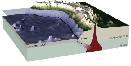
A
NASA subduction diagram
“Description: The majority of earthquakes and volcanoes around
the world occur at the intersection of plate boundaries. This diagram
shows the subduction of an ocean plate underneath a continental plate.
Earthquakes are caused by the two plates moving relative to each other,
and volcanoes are formed when ocean crust, forced under the lighter
continental crust, melts and then rises to the Earth's surface. The
Andes have been forming over the past 170 million years as the Nazca
Plate lying under the Pacific Ocean has forced its way under the South
American Plate and pushed up its western edge. The subduction of one
plate under the other has given rise to a number of volcanoes that
dot the western edge of the mountain range.”
Diagram showing overthrust
and subduction areas in Sumatra region.
|
landslips
A very long and useful item on the risk
of landslide/landslip-generated tsunamis (illustrated). The Canary
Islands and Hawaii are discussed in detail.
| Tambora [ from Enc. Brit.]
- The largest eruption since 1700 occurred at Tambora Volcano
on Sumbawa Island, Indonesia, on April 10-11, 1815.
- Fifty cubic kilometres of magma were expelled
in Plinian ash clouds and pyroclastic flows.
- Ash greater than one centimetre thick fell on more than 500,000
square kilometres of Indonesia and the Java Sea.
- Before the eruption Tambora was a 4,300-metre-high stratovolcano;
following the eruption 1,400 metres of the summit cone were missing
and in its place was a collapsed caldera measuring six by seven
kilometres wide and one kilometre deep.
- About 10,000 people were killed by the explosive eruption and
the tsunamis caused by massive pyroclastic flows entering the
sea.
- Agricultural losses from the thick ash deposits resulted in
famine and disease, leading to an additional 82,000 deaths.
Fifty cubic kilometres is approximately 12
cubic miles [1 cubic km ~ 4.168 cubic miles], the amount a 500-yard
diameter asteroid could be expected to throw into the air, assuming
a 50,000 mph impact.
Krakatoa (Also in Indonesia)
The second largest eruption of the 19th century also occurred
in Indonesia. Krakatoa (or Krakatau), a compound volcano on a small
uninhabited island between Sumatra and Java, erupted explosively
on 26-27 August, 1883. The eruption was similar to the Tambora outburst
but smaller, involving only about 18 cubic kilometres of magma erupted
in Plinian ash clouds and pyroclastic flows. Krakatoa was a much
smaller volcano than Tambora, and when the eruption had emptied
its magma chamber, it collapsed to form a caldera that was partly
below sea level.
Twenty-three square kilometres of the island of Krakatoa disappeared,
and where a volcanic peak 450 metres high once stood was water as
deep as 275 metres. The largest explosion on the morning of August
27 produced an ash cloud that was reported to have reached 80 kilometres
high, and the detonation was heard in Australia, 4,800 kilometres
away. A tsunami, over 30 metres high, followed the explosion and
apparent caldera collapse, killing about 36,000 people on the adjacent
shores of Java and Sumatra. |
asteroids
and meteors
About one third of the world is land, so an asteroid or meteor impact
is more likely to occur at sea.
On a big messy site about tsunamis with vast numbers of links, there
is a section
on asteroids.
Large asteroids also form a ‘chimney’ in the atmosphere,
by which large quantities of material may be sucked into the atmosphere.
Thus the effect of an asteroid can be greater than a major volcanic eruption.
The Tambora event in 1815 (also in Indonesia)
is associated with “the
year with no summer”, causing major crop failures around the
world.
The effects of large amounts of water being vapourised and ejected into
the upper atmosphere is yet unknown. Remember, water vapour is a major
greenhouse gas.
There are approximate frequencies of asteroid/meteor impact by size,
as calculated from past data. The force of an asteroid varies with size
and speed of impact. It has effects similar to a pebble dropped in a pond,
but can be a damned big, fast pebble.
| approximate
probabilities of various levels of strike impact |
| impact diameter |
kinetic energy |
area devastated |
average. interval
(years) |
| (m) |
Mt TNT |
sq km |
Earth |
‘city’ |
inhabited region &
expected death toll |
| 50 |
10 |
1900 |
100 |
30,000,000 |
900 yr
1,000,000 |
| 100 |
75 |
7200 |
1000 |
70,000,000 |
8000 yr
3,000,000 |
| 200 |
600 |
29,000 |
5000 |
90,000,000 |
30,000 yr
14,000,000 |
| 500 |
10,000 |
70,000 |
40,000 |
290,000,000 |
180,000 yr
30,000,000 |
| 1 km |
75,000 |
200,000 |
100,000 |
260,000,000 |
290,000 yr
60,000,000 |
| 2 km |
1,000,000 |
- |
1,000,000 |
- |
1 ,000,000 yr
1.5 billion |
based on the impact of a stony asteroid,
assuming velocity=20km/s[approx. 72,000 kph/45,000 mph], density=3
g/cc |
Table derived from section
on asteroids. You want to study asteroids further? Go to the linked
site!
Acknowledgement
With additional research from the
auroran sunset, (detail
reporting).
|
end notes
- Ordinary ocean and lake waves are formed by the
friction of wind on the water. Thus, they are kicked up according to
the intensity of the wind. Waves are not a movement of water forward,
the movement only is transmitted through the water, molecule to molecule.
Hence, the speed of a tsunami can be much greater, because of the much
greater generating forces.
A tectonic plate slip can be a very fast, explosive event. Think in
terms of bending a stick, where the tension gradually increases and
then suddenly, the stick snaps.
|
|


